The Lost City 2005
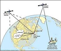
 This exploration introduced a new methodology for marine fieldwork. Scientists used satellites to view and analyze data without being on a ship at sea.Live pictures of the white chimneys of Lost City will travel from 2,100 feet below sealevel to the NOAA ship Ronald H. Brown, across the Atlantic Ocean to the University of Rhode Island and then across the USA to scientists at University of Washington in Seattle.
This diagram shows how video and data will be transmitted between the NOAA ship Ronald H. Brown, via satellite and Internet 2, to the Inner Space Center at URI, the University of Washington, and other participating sites.In less than 2 seconds live video will have traveled over 5,000 miles. With new technology, many scientists and students will be able to view and analyze data without being on a ship at sea. It is the introduction of a new methodology for marine fieldwork. On this expedition our underwater cameras will explore Lost City.
Space shot to our own planet: ROV Hercules approaches a ghostly, white, carbonate spire in the Lost City Hydrothermal Field, about 2500 feet below the surface of the Atlantic Ocean.
In 2000 a remarkable discovery occurred. Cruising over a large mountain west of the Mid-Atlantic Ridge scientists using underwater cameras sighted strange 90 to 200 foot white towers. This was the discovery of a completely new kind of underwater hot spring environment unlike any seen before. We now call these springs the Lost City Hydrothermal Field (LCHF). This expedition will explore LCHF 24-hours a day for 10 days using IFE's Remotely Operated Vehicles (ROV's) Argus and Hercules and immediately transmitting that data to scientists on-shore.
 Deep Sea Crabs