U.S. Temperature Above Normal in July - August 8, 2008
July 2008 was the 30th warmest July for the contiguous United States, based on records dating back to 1895, according to an analysis by NOAA's National Climatic Data Center in Asheville, N.C. The average July temperature 74.9 degrees F was 0.7 degrees above the 20th century mean, based on preliminary data.

U.S. Temperature Above Normal in July
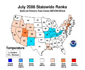
- July temperatures were generally higher than average across the West and Northeast and below average in the Midwest.
- Five states (Conn., Mass., N.J., R.I. and Utah) were much warmer than average. Rhode Island had its sixth warmest July, and Massachusetts and Utah both had their eighth warmest July, based on statewide data going back to 1895. Six states (Ill., Ind., Ky., Mo., N.M. and W.Va.) were cooler than average.
- Based on NOAA's Residential Energy Demand Temperature Index, contiguous U.S. temperature-related energy demand was approximately three percent above average in July.
U.S. Precipitation Highlights
- An average of 2.90 inches of precipitation fell across the contiguous United States in July, which is near the 20th century average of 2.76 inches./li>
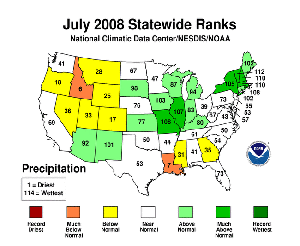
- Seven states (Ill., Mass., Mo., N.H., N.Y., R.I. and Vt.) were much wetter than average, with Vermont having its third wettest July on record. Massachusetts and New Hampshire had their fifth wettest July./li>
- Idaho and Louisiana were much drier than average, with Idaho having its sixth driest July on record and Louisiana its seventh driest July./li>
- The lack of significant rainfall across the Southeast had little impact on drought conditions. At the end of July, 59 percent of the region was classified in moderate-to-exceptional drought, based on the U.S. Drought Monitor. For the contiguous U.S., about 28 percent of the nation was in moderate to exceptional drought.
Midwest Flooding

Heavy rains fell across parts of the Midwest again in July, continuing a trend that began last October. An area from central Iowa through northeastern Missouri and western Illinois accumulated more than twice the normal July rainfall. At Long Branch Reservoir in north central Missouri, 18.64 inches fell - more than three times the normal amount. The heavy rains triggered widespread flash flooding in Missouri and Iowa. Mark Twain Lake in Missouri reached a record of 640.36 feet above mean sea level on July 30. Illinois and Missouri had their wettest January to July on record.
Wildfires
Continued dry conditions in July across northern and central California hindered efforts to contain a dozen large wildfires. Large fires also developed last month in other states, including Texas, Oklahoma, and North Carolina. From January 1st to July 31st, 53,796 wildfires have burned more than 3.5 million acres of the United States, according to statistics from the National Interagency Fire Center. This activity is close to the 1999-2008 average and well below the year-to-date extent of the past two years.
Other Events
- A rare EF-2 tornado struck in New Hampshire on July 24 and claimed one life and injured several others.
- Hurricane Bertha formed in the tropical Atlantic on July 3, and while not making landfall, was the longest-lived, pre-August Atlantic tropical cyclone on record. It became extratropical on July 20. The same day, Hurricane Dolly developed in the Caribbean Sea and made landfall as a Category 2 hurricane at South Padre Island, Texas on July 22. Dolly is the most intense tropical cyclone to make U.S. landfall since Hurricane Wilma in 2005.
- Heavy rain from Tropical Storm Dolly brought relief from drought across parts of the Southwest and in southern Texas. However, up to eight inches of rain fell within 36 hours over parts of southern New Mexico, resulting in many flash floods, which claimed one life, and brought total property damage estimates of around $1.5 billion.
NOAA understands and predicts changes in the Earth's environment, from the depths of the ocean to the surface of the sun, and conserves and manages our coastal and marine resources.
 Deep Sea Crabs